

If you look at an Oʻahu forecast from the mainland, it can seem almost useless: rain symbols stacked across the week, a “chance of showers” every day, wind that sounds stronger than it feels at the beach. Then you arrive in Waikīkī and spend three dry hours in the sun while clouds sit over the Koʻolau mountains like they have an appointment there.
That is not the forecast failing. It is Oʻahu behaving like Oʻahu.
The island’s weather is not one big blanket laid evenly over Honolulu, Kailua, Haleʻiwa, and Waiʻanae. It is a moving conversation between wind, ocean moisture, mountain ridges, and season. Once you understand the basic patterns—trade winds, Kona winds, Kona storms, rainy season, and microclimates—the island becomes much easier to read.
The normal setting: trade winds from the northeast
Most of the time, Oʻahu is shaped by trade winds: the familiar northeast-to-east breezes that keep the island from feeling as hot and still as it otherwise would.
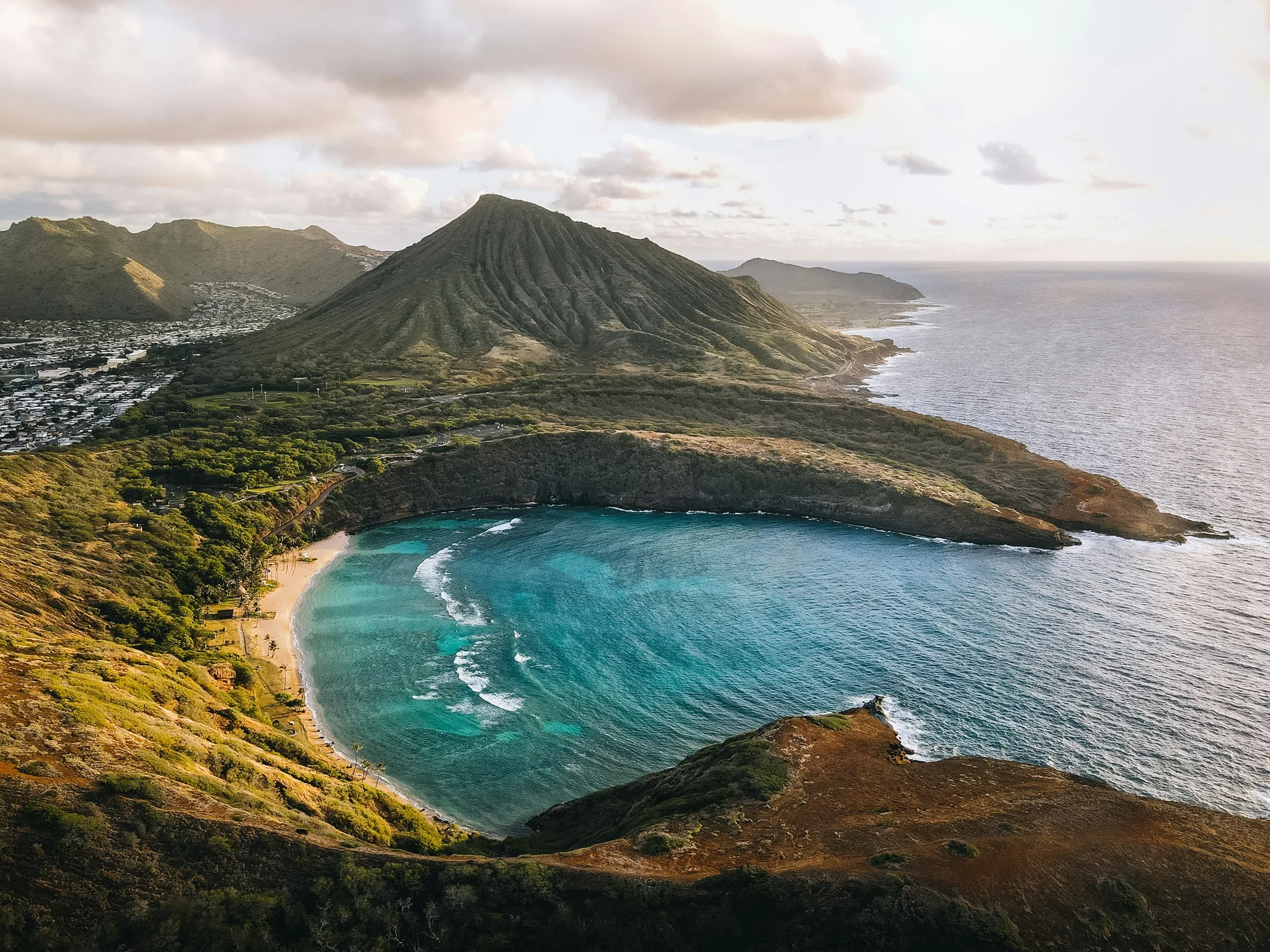
The Koʻolau Range does much of the visible work. When trade winds push moist air toward Oʻahu, that air rises along the windward side—the side facing the incoming trades. As it rises, it cools, clouds form, and showers develop. This is why areas around Kāneʻohe, Kailua, Waimānalo, and the green valleys against the Koʻolau often see more cloud and passing rain than the south and west sides.
Leeward areas sit in partial rain shadow. Waikīkī, urban Honolulu, ʻEwa, Kapolei, Ko Olina, Waiʻanae, and Mākaha can be much drier on an ordinary trade-wind day, even when the mountains look dark and wet. You may leave a misty Nuʻuanu or Mānoa morning and arrive in a dry Ala Moana afternoon without feeling like you changed islands—only weather zones.
The practical takeaway is simple: on trade-wind days, don’t read “showers on Oʻahu” as “your whole day is washed out.” Often it means windward and mountain showers, with clearer breaks on the leeward coast.
Why Waikīkī can be sunny while the mountains are gray
For many visitors, Waikīkī becomes the default weather reference point. That makes sense: it is where many people stay, and it often delivers the warm, dry beach weather people came for.
But Waikīkī is not representative of all Oʻahu. It sits on the south shore, away from the direct hit of the trades and somewhat sheltered by the island’s terrain. On a typical day, clouds may build along the Koʻolau behind Honolulu while the beach remains bright. From a hotel balcony, the island can look rainy inland and sunny at the shoreline at the same time.
This is one reason forecasts can feel overly pessimistic. A forecast zone may include mountains, valleys, and coastline together. If the mountains are likely to catch showers, the icon may show rain even though the south shore has long dry stretches.
The reverse is also true. A blue morning in Waikīkī does not guarantee a dry ridge hike, a clear lookout, or sunshine over Kailua. On Oʻahu, a few miles and a few hundred feet of elevation can matter.
Windward, leeward, and North Shore patterns
Oʻahu’s windward side is where the trade-wind pattern is most obvious. Kāneʻohe, Kailua, Waimānalo, Kualoa, and the coastal communities beneath the Koʻolau tend to be more open to passing showers and cloud banks.
This does not mean “bad weather.” Windward Oʻahu is often at its loveliest when clouds are moving quickly: sunlight on the water, green cliffs in the background, a five-minute shower, then blue again. The rain is part of why the area looks the way it does.
The leeward west side—Kapolei, Ko Olina, Waiʻanae, Mākaha, and the coastal stretch below the Waiʻanae Range—is one of the island’s drier visitor areas. On a classic trade-wind day, it can be bright and warm while the Koʻolau are wearing clouds.
But “usually dry” does not mean “immune.” When winds turn southerly or southwesterly, or when a Kona system develops, leeward Oʻahu can receive the weather first. Areas that are often sunny may turn humid, cloudy, and wet.
The North Shore has its own rhythm. It is not as consistently windward as Kāneʻohe or Kailua, and not as reliably dry as the far west side. Around Haleʻiwa, Waialua, Pūpūkea, and Sunset Beach, weather shifts with wind direction, nearby mountain influence, and season. In winter, when surf gets much of the attention, the atmosphere is also more variable. In summer, the North Shore often feels calmer and sunnier, though local showers still occur.
The main thing to remember: Oʻahu does not divide neatly into “sunny side” and “rainy side.” Each region responds to the pattern of the day.
Kona winds: when the weather map turns around
Kona winds are the pattern that makes regular visitors do a double take.
Instead of the normal northeast trades, winds come from the south or southwest. The familiar windward-leeward logic weakens or reverses. Moisture can move toward the island from the “wrong” direction, bringing clouds and rain to south and west-facing areas that are normally drier.
For visitors, this often feels like a sticky, still day in Honolulu, hazier skies, and rain where you did not expect it—perhaps Waikīkī, ʻEwa, Ko Olina, or the Waiʻanae Coast. Windward areas may be calmer than usual, and at times can even feel more protected.
Kona winds are not automatically severe. Sometimes they simply mean humid air, lighter breezes, and a strange reversal of the usual pattern. But they are worth noticing because they change the basic rules of the island. If the forecast mentions Kona winds, do not assume your usual “go leeward for sun” strategy will work.
Kona storms: the stronger, slower version
A Kona storm is more organized and more consequential than ordinary Kona winds. These systems are associated with low-pressure patterns that can draw deep moisture over the islands and linger.
On Oʻahu, that can mean widespread cloud cover, heavier rain, and more persistent weather than the quick showers people associate with the trades. South and west-facing areas can be especially exposed depending on the setup, but strong Kona storms can affect the whole island.
This is one of the few times when it makes sense to treat the forecast as a real trip-planning factor rather than background noise. Keep plans flexible, avoid building the day around exposed views, and choose activities that do not depend on perfect sky conditions.
The good news is that Kona storms are not the everyday norm. They are memorable precisely because they break the usual pattern.
Rainy season does not mean it rains all day
Oʻahu’s wetter season generally falls during the cooler months, when larger weather systems are more likely and the atmosphere is more variable. But “rainy season” is a broad tendency, not a daily sentence.
A winter trip can bring brilliant beach days. A summer trip can still have showers. The difference is probability and personality: in the wetter months, you have a higher chance of unsettled patterns, heavier showers, or a multi-day system. In the drier months, trade-wind showers are still part of the island, but long stormy periods are generally less common.
This matters most for expectations. If you are visiting in winter, do not be shocked by a forecast that looks mixed. Put the most weather-dependent plans on the best-looking days, and leave flexible meals, museums, shopping, or town time for cloudier stretches.
Microclimates: the reason there is no single Oʻahu forecast
“Microclimate” can sound like travel brochure language, but on Oʻahu it is practical. The island is small enough to cross in a day, yet varied enough that weather changes quickly by region.
A few common contrasts:
Waikīkī and urban Honolulu can be warm and dry while Koʻolau clouds sit just inland. Mānoa, Nuʻuanu, and Tantalus can be misty or showery when the south shore is dry. Kailua and Kāneʻohe often catch trade-wind showers and cloud movement. Ko Olina, Waiʻanae, and Mākaha are often drier under trades, but more exposed during Kona patterns. North Shore communities shift depending on wind direction, season, and broader systems. Central Oʻahu can feel warmer and less ocean-cooled, especially away from shoreline breezes.
The island is not random; it is patterned. But the pattern is local.
How to use this without overthinking it
You do not need to become a meteorologist to plan a good Oʻahu day. You only need to ask better questions than “Will it rain?”
Ask:
Which direction is the wind coming from? Is this a normal trade-wind pattern or a Kona pattern? Are showers mostly windward and mountain-focused, or islandwide? Is the weather moving quickly, or is a larger system sitting over the island? Am I planning something that truly needs clear skies, or just a pleasant day?
If the trades are steady and the forecast shows scattered showers, you can often work with that. Maybe the windward side has passing rain while the south shore stays dry. If Kona winds are in play, reconsider assumptions: the places that are usually driest may not be. If a larger storm is forecast, keep the day lighter and let the island set the pace.
That is the real lesson of Oʻahu weather: the island is legible once you learn its language. Trade winds paint the Koʻolau green. Leeward coasts hold the sun. Kona patterns rearrange the map. Rainy season raises the odds, not the curtain. And somewhere, almost every day, Oʻahu is doing more than one thing at once.

Further Reading
A few relevant next steps from Alakai Aloha.
 BlogA Rainy-Day Backup Plan for Oʻahu
When Oʻahu turns wet, use local weather patterns, safer swaps, and indoor ideas to pivot your day without giving up the trip you planned.
Editor's pick ToolCompare island weather by region
See how rain, wind, and conditions vary around the island before you choose your day plan.
Useful planning tool BlogWhen to Visit Oʻahu for Your Best Trip
Use this month-by-month Oʻahu guide to weigh Waikīkī weather, North Shore surf, crowds, hotel prices, and events so you can time the trip that fits you best.
Editor's pick BlogA Nervous Flyer’s Guide to Oʻahu Helicopter Tours
How to choose an Oʻahu helicopter tour with more confidence, from operator questions and aircraft styles to weather calls, doors-off concerns, and comfort-first alternatives.
Editor's pick