

A closed trail on Oʻahu can feel like the island just erased the best part of your day. Usually, it means you need a cleaner pivot: same side of the island if the weather still works, different terrain if it does not.
Oʻahu rewards flexibility. A ridge can be socked in while the south shore is bright. A waterfall trail can turn sloppy after rain while a coastal path stays dry. A popular trailhead can be inaccessible while a lookout ten minutes away gives you the view without the parking drama.
The trick is not to “find another hike” automatically. The trick is to understand *why* your original plan fell apart, then choose a Plan B that does not run into the same problem.
First, identify the closure type
Before scrolling for alternatives in the parking lot, sort the closure into one of three buckets.
Weather closure or bad conditions Heavy rain, muddy ridges, swollen streams, high surf, or wind can make a whole category of plans less appealing. If Mānoa is soaked, another shaded Koʻolau valley trail may not be the clever workaround. If the coast is getting pounded by surf, a shoreline scramble is not a better idea.
Access closure This includes parking limits, neighborhood access issues, construction, managed-entry systems, or a full lot that effectively closes the option for you. The trail may be fine; the logistics are not. A nearby lookout, garden, beach walk, or town stop can save the day without turning the morning into a traffic loop.
Site-specific closure Sometimes one trail, bridge, park section, or viewpoint is closed while the surrounding area still works. This is the easiest pivot: stay in the region, change the shape of the outing.
For official status, check the agency or manager responsible for the place: Hawaiʻi State Parks for state parks and monuments, Nā Ala Hele for state trails, City and County of Honolulu for city parks, and the site’s own page or visitor contact when it is privately managed or reservation-based. Third-party comments can be useful for mood, but they are not the final word.
The Oʻahu Plan B rule: change the terrain, not just the trail
Oʻahu’s hiking patterns are shaped by the Koʻolau and Waiʻanae ranges, plus a lot of visitors trying to do the same famous trails from Waikīkī. When one plan closes, the smartest move is often to switch terrain:
Muddy ridge or waterfall trail closed? Choose a paved coastal path, lookout drive, botanical garden, museum, or town stop. Hot, exposed climb not working? Move to shade, a garden walk, or an early-evening shoreline stroll. Parking or access failed? Pick a managed site, lookout, or walkable urban plan instead of circling a residential trailhead. Clouds hiding the mountain view? Go lower: coast, gardens, food, history, or a scenic drive.
A good Plan B should feel intentional, not like a consolation prize. On Oʻahu, that usually means trading one kind of beauty for another.
If your Honolulu or Waikīkī-area hike closes
Many visitors build an Oʻahu hiking day around Lēʻahi, Mānoa, or the Tantalus/Round Top area because they are close to Waikīkī. If that plan breaks, do not burn the morning zigzagging across the island.
For a view without a muddy trail
The Tantalus and Round Top drive is one of Honolulu’s best pressure-release valves. If the weather is cooperating, trade a hike for a slow, curving drive above the city, with forest, old lava ridges, and broad views over Honolulu. Puʻu ʻUalakaʻa State Wayside is the classic stop in this area when conditions are clear.
This works especially well when you wanted a “mountain above the city” feeling but not necessarily a long hike.
For a rain-friendly nature day
If valley trails are sloppy, lean into cultivated landscapes instead of fighting the mud. Honolulu’s botanical gardens and arboretum-style settings give you the green, humid, tropical mood without requiring a technical trail day: trees, plants, birds, old stone, water, shade.
That may not scratch the same itch as a ridge summit, but after rain it can be the better version of the day.
For a full indoor pivot
When the weather is truly unhelpful, go cultural rather than forcing a second outdoor plan. Bishop Museum and ʻIolani Palace are strong Honolulu anchors, especially if your original hike was part of a larger effort to understand the island beyond beaches and resort space. Build the rest of the day around food, a neighborhood walk, and an early dinner instead of chasing dry dirt.
If your East Honolulu hike closes
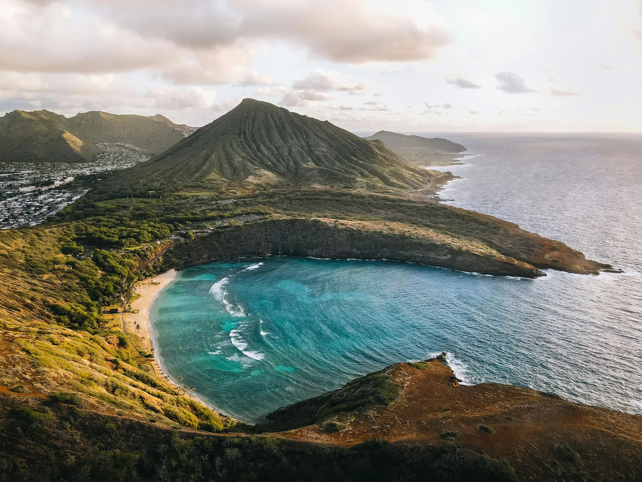
East Honolulu is where many visitors look for a high-energy day: Koko Crater, Makapuʻu, Hanauma Bay, Sandy Beach, Halona, and the coastline toward Waimānalo. The terrain is drier and more exposed than the Koʻolau valleys, so the decision is less about mud and more about heat, wind, access, and ocean conditions.
Makapuʻu Point Lighthouse Trail is often the cleanest alternative when you still want movement, ocean views, and a defined route. It has a very different feel from a stair climb or rough trail: more open sky, more sea, less jungle. Nearby scenic stops along the coast can fill out the day without overplanning.
If the issue is heat or exposure, do not replace one hot, exposed route with another simply because it is famous. East Honolulu can feel harsh by late morning: bright rock, little shade, trade winds that help but do not erase the sun. Pivot toward a shaded meal, a beach with an easy exit, or the windward side rather than turning the morning into a test.
A coastal walk can be enough. On Oʻahu, not every good outdoor day needs to end at a summit.
If your Windward-side trail closes
The windward side is generous and moody: green cliffs, passing showers, big cloud movement, and some of the island’s most photogenic drives. Closures here often come down to rain, mud, stream conditions, or managed access.
If your planned windward hike closes because of weather, think twice before choosing another lush valley trail nearby. The same rain that made one trail unpleasant may be working on the next drainage over.
Hoʻomaluhia Botanical Garden is a natural pivot for many windward plans. It gives you the Koʻolau wall, water, lawns, palms, and mountain atmosphere with a much easier rhythm than a muddy climb. It is the kind of place where a failed hike can turn into a slower, better morning if you let it.
The Byodo-In Temple area can also fit a windward Plan B when you want a contemplative stop rather than another physical objective. Pair it with a drive through Kāneʻohe or Kailua depending on where your day was already headed.
Kailua and Lanikai draw plenty of attention, but the better Plan B is not always “go to the most famous beach.” It is choosing the version of the windward side that matches the day: coffee and a stroll if showers are passing through, a protected-feeling beach visit if conditions are comfortable, or a drive-and-lookout day if the mountains keep disappearing into cloud.
If your North Shore plan closes
North Shore trail closures can be especially frustrating because many travelers have already committed to the long drive. The good news: the North Shore is one of the easiest places on Oʻahu to turn a lost hike into a complete day.
Waimea Valley is the most obvious Plan B when you want a managed nature walk, cultural landscape, and a waterfall setting without improvising on an unofficial trail. It is not a wilderness hike, and that is the point. When conditions, access, or timing make a rougher trail a bad fit, a managed valley experience can be exactly right.
If a ridge trail is closed because of mud or access, do not chase every nearby ridge on the map. North Shore slopes can be slick, eroded, and crowded at the same time. Instead, let the day widen: Haleʻiwa for food and shops, beach time where conditions look inviting, and scenic stops along the coast.
If Kaʻena Point was your plan and your chosen access is closed or conditions look wrong, do not assume the other side is a quick fix. Treat it as its own plan, not a casual add-on. A solid pivot is to keep the day coastal but less committing: North Shore town time if you are on the Mokulēʻia side, or a leeward coast plan if you are coming from the Waiʻanae side.
If your leeward or central Oʻahu trail closes
Leeward Oʻahu is drier, warmer, and more spread out than many visitors expect. Central Oʻahu often works as a useful pivot zone when weather is split between the Koʻolau side and the south shore.
If a leeward hike closes, first consider whether the issue is heat, access, or road conditions. A replacement hike in the same exposure may not improve the day. Pearl Harbor-area history, Wahiawā garden stops, or a relaxed west-side coastal plan can make more sense than forcing another trail.
The Waiʻanae Range has a different personality from the Koʻolau side: drier ridges, sharper light, and fewer convenient visitor facilities in some areas. Give it more margin. If the original plan is off, choose a simpler day rather than stacking ambitious substitutes.
A simple Plan B formula that works on Oʻahu
When the closure notice appears, build the next plan in this order:
1. Stay on the same side of the island if the weather is still good. This saves the day from becoming a traffic project. 2. Change terrain if weather caused the closure. Muddy trail becomes coastal path, garden, lookout, or museum. 3. Choose one anchor, not five. A good Plan B has a center: Makapuʻu, Hoʻomaluhia, Waimea Valley, Tantalus, Bishop Museum, Kailua, or Haleʻiwa. 4. Leave room for food. Oʻahu is much kinder when you stop treating every hour as a scheduled attraction. 5. Do not try to outsmart a closure sign. A closure is simply information. Accept it quickly and you get your day back.
The best Oʻahu days are not always the ones that follow the saved itinerary. Sometimes the mountain is wrapped in cloud, the parking lot is full, the trail is under repair, or the valley is too wet to enjoy. That is not the island rejecting your plan. It is the island giving you a different one.
A closed hike can become a lookout morning above Honolulu, a windward garden walk under the Koʻolau cliffs, a North Shore lunch-and-beach day, or a museum visit that gives the rest of the trip more meaning. On Oʻahu, there is almost always a next good thing.

Further Reading
A few relevant next steps from Alakai Aloha.
 BlogOʻahu’s Most Scenic Drives and Road Trips
Choose the right Oʻahu route for your mood, from wave-lashed southeast cliffs to windward valleys and North Shore beach roads.
Editor's pick ActivityBishop Museum
The Bernice Pauahi Bishop Museum is Hawaii's premier museum, offering a deep dive into Polynesian cultural artifacts, natural history, and interactive science exhibits perfect for all ages.
Editor's pick ToolCompare island weather by region
See how rain, wind, and conditions vary around the island before you choose your day plan.
Useful planning tool ActivityIolani Palace
Explore the only official state residence of royalty in the U.S., immersing yourself in the rich history of the Hawaiian monarchy and its pivotal role in island culture.
Editor's pick